 Plotted this morning's run using the ' measure: path' tool on google earth. Came out around 18.4ks which we did in 88 mins (about 4.45ks). My first "Wednesday Long Run" as organised by Matty with a start at 5.30am at the Ship Inn. Also joining us was Beth who I recognised from the B2B 45min pace group. A whole heap of other PCRGers milling around, almost thought Pat was going to make an appearance, but they headed off on their own long run.
Tenz came along & was keen to make an impression. He can start to flag on the hills but I strategically placed him behind the others to give him a target to chase. It was cold enough that we only took 2 short stops for water at fountains.
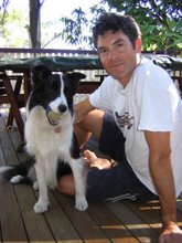
Beth did the Everest trek in Nepal earlier this year & it reminded me of the origin of Tenzing's name. The first time I trekked up Kalar Patar on the Everest trek I was accompanied by a black & white dog who was keen to show me the way. I was reminded of that guy when I saw T & rather than go the traditional Scottish naming theme for a Border Collie thought we'd do the non-traditional Sherpa / Tibetan option.

2 comments:
What are all those blue spots?
The Green Bridge has opened up a lot of running possibilities
The blue spots are links to sites & sights that folks add to their cities, e.g. a photo taken from that spot. You don't have google earth?
Post a Comment